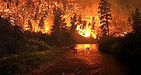
This website facilitates integration of comprehensive climate, weather, situation and fuels information in geospatial format. Predictive Services personnel at the National Interagency Fire Center (NIFC) and Geographic Area Coordination Centers (GACCs) utilize these data to produce daily, weekly, monthly and seasonal Fire Weather and Fire Danger Outlook products that provide decision support information to anticipate fire activity. Note, if the images do not load you will need to download the Flash plug-in.
Map Products
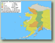
7-Day Significant Fire Potential Maps - View and print PDF maps of the current Predictive Services products.
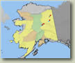
Interactive Map
View current 7-day forecast of significant fire potential for Alaska in context of additional GIS datasets in a web mapping service.
Instructions
Instructions on how to use the map viewers and data on this site most effectively.
Links and Q & A
Frequently asked questions relating to the data and products provided on this website.