About Us
The availability of current and explicit geospatial information characterizing the location and intensity of fire activity is essential for tactical wildfire management. USDA Forest Service National Infrared Operations (NIROPS) addresses this operational need through effective acquisition, pre-processing and near real-time delivery of high resolution airborne infrared imagery and fire detection data to infrared interpreters IRINs). The timely availability of acquired imagery and derived data enables infrared interpreters to generate tactical scale fire mapping products that support situational awareness and informed decision-making by incident command teams.
In the early 1960s, the Forest Service began research into the use of thermal infrared technology to support wildfire suppression efforts. Since the late 1960s, the Forest Service has conducted thermal imaging and fire detection operations for the agency and the broader interagency wildfire management community. Today, NIROPS conducts nationwide support operations through coordination between Region 4 Fire and Aviation Management (F&AM) and the National Infrared Program Manager. Relevant technical assistance to NIROPS is provided by the Geospatial Technology and Applications Center (GTAC). NIROPS roles and responsibilities for these entities are summarized below.
National Infrared Program Manager:
- Coordinate with National Interagency Coordination Center, IR technicians, and R4 pilots on status of aircraft and equipment.
- Manage the group of qualified and trainee Infrared Interpreters.
- Coordinate with contract IR vendors on aircraft and IR equipment.
Region 4 F&AM:
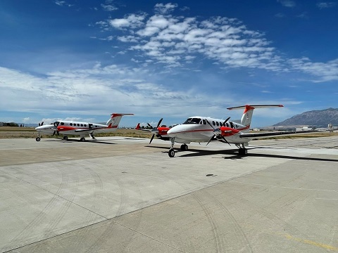
- Maintain and provide two aircraft platforms for operational NIROPS and fire detection support.
-
Beechcraft Super King Air 200GT - N115Z and N181Z
-
Beechcraft Super King Air 200GT - N115Z and N181Z
- Coordinate and conduct daily NIROPS mission planning operations.
- Pilot and operate aircraft for NIROPS missions during the active fire season, typically May-November.
NIICD Infrared Branch:
- Maintain and manage Forest Service airborne thermal infrared sensor systems.
- Coordinate and conduct NIROPS mission planning operations with Region 4 F&AM flight crews.
- Provide onboard support to monitor, acquire, pre-process and deliver imagery during NIROPS missions.
- Coordinate sensor system hardware and corresponding software upgrades.
- Provide software development and technical support for infrared sensor command and control.
- Provide software development and technical support for real-time image pre-processing and data extraction.
GTAC:
- Coordinate with NASA and the private sector to stay current on the latest airborne remote sensing instruments and related technologies of interest to NIROPS.
- Manage and maintain the online infrared ordering system used by wildland fire incidents to request NIROPS support.
- Provide technical support for NIROPS operations and technology transfer to infrared interpreters.
View sample Phoenix imagery.